Are YOU in the Right-of-Way?
Take a look at the East-West Connector Route Design just east of I-35

Traditionally, new alignment transportation planning is done at the behest of the people through their elected representatives. The people might see a need and then ask their City and County to help and then the City and County ask the State to help and then the State asks the Federal Government to help pay for it… with OUR TAXES.

There is so much more to say about our broken federal infrastructure funding system that primarily funds NEW builds rather than funding MAINTENANCE needs on all the infrastructure we’ve already built….. but that’s for another post.
But when the federal government gets involved, there are tons of environmental regulations and public input requirements that allow the people to get the best solution - including a NO BUILD OPTION.
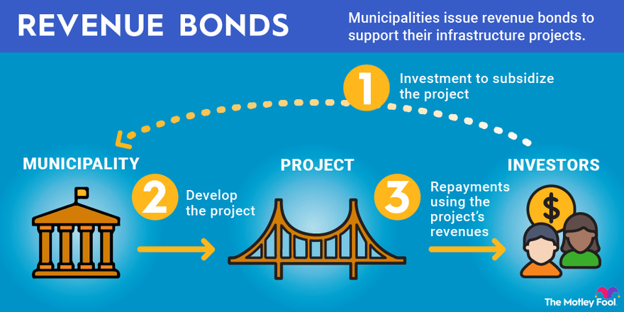
The OTA uses revenue bond money - not federal or state dollars - so you you already know that there is no WILLING entity that can FORCE the OTA to survey, study, plan and build within standard guidelines and best practices.
There are federal entity’s that can REFUSE permits to cross federal and wetlands, and the U.S. Bureau of Reclamation (BoR) has done so with one of our projects. We hope that the U.S. Army Corps of Engineers will help us force an environmental impact study on the Canadian River Crossing before ruling on a 404 permit, but their record is not great when it comes to proactively telling the OTA to cease and desist.
The LEGISLATURE can force the OTA to survey, study, plan and build within standard guidelines and best practices with law changes, and the JUDICIAL branch can uphold the legislative intent with intellectually honest rulings, but both are largely compromised and part of the money cartel, and so We the People are largely left without representation and recourse.

The Oklahoma Turnpike Authority (OTA) doesn’t build roads based on transportation NEED. I mean come on…. 9 of their 12 turnpikes have been LOSING money since conception. It never matters if their roadways are needed or will generate enough revenue to pay their bond debt off and maintenance needs. They build roads to keep the money flowing to their banking, developer and transportation mafias.
Just think of it this way. The OTA actually functions as a BANK with billions of dollars in debt that they want to keep paying the interest on to make their banking friends money. There is no incentive to PAYOFF THE DEBT. Why? If they payoff their debt their roadways become FREE to the public, per statute, and then the lending institutions don’t keep raking in the interest monies.

In addition, without a steady flow of “new bonds,” to pay off their “old debt,” the OTA can’t keep “washing” other money through their system. But the only way they can keep the shill up is to sell more BONDS to BUILD MORE ROADS to keep the money flowing to their debtors. And here we are.
Mapping the ACCESS Project
Even though I have read the Turnpike Enabling Act several times, I still can not believe that the OTA can legally keep their roadway planning secret from the public and not participate in regional planning exercises. I also cannot believe that they can commence engineering design of roadways WITHOUT AN ENVIRONMENTAL or HUMAN IMPACT STUDY. What happens when they get the designs done and then find out there is an environmental problem or they end up taking out more people than ANY OTHER INFRASTRUCTURE PROJECT IN OKLAHOMA?
Oh right… they just make sure they get too far along so no agency has the guts to stop them.
They did just this on the controversial Creek Turnpike (subscription to Tulsa World necessary) in the early 1990’s. The OTA REFUSED to do an environmental impact study on a bridge crossing of a wetland even though the U.S. Army Corps of Engineers and the U.S. Fish and Wildlife Service requested one because the OTA said the road wasn’t being build with federal dollars. And guess what? The OTA built the roadway to the edges of the Creek and Governor Bellmon skipped the regional delegation and went straight to DC to get the Corps to issue the 404 permit allowing construction in wetlands - WITHOUT AN ENVIRONMENTAL IMPACT STUDY. They will do it again here if we can’t stop the OTA from starting construction.
Here is the Tulsa World article in its entirety.


This is absolutely disgusting and the antithesis of the Civil Engineering Code of Ethics and it needs to be changed in the Oklahoma Constitution.
Around March 2022, I open record requested the mapping of the planned ACCESS routes. In June of 2023 (nearly 15 months after my request), I received this OTA KMZ file dated March 17, 2022 that shows the breakdown of engineering design and preliminary costs for the proposed ACCESS routes.

Map Legend
TriCity = 8 miles = $170 MILLION
(As of July 8, 2024, now $250 MILLION) - 47% increase in price
Orange = MacArthur (TCC-29001 for $60M, TCC-29002 for $110M) - NOT ACTIVE
East-West Connector = 28 miles = $1.27 BILLION
(As of July 8, 2024 now $1.5 BILLION) - 18% increase in price
Blue = MacArthur (EWC-28001 for $80M and EWC-28002 for $80M) - ACTIVE
Red = TEIM (EWC-28003 for $70M and EWC-28004 for $320M which is the I35 interchange) - ACTIVE
Green = MKEC (EWC-28005 for $160M - that’s $35.5M/Mile build 4.5 miles. Holy smokes. No wonder these engineering and construction firms are sucking up to the OTA and are willing to go against their code of ethics to screw the public.) - ACTIVE
Yellow = EST (EWC-28006, 3 miles for $120M and EWC-28007, $140M including South Ext. Interchange) - NOT ACTIVE
Orange = CEC (EWC-28008 for $70M and EWC-28009 for $90M and EWC-28010 for $140M) - ACTIVE
Southern Extension = 19 miles = $520 Million
(as of July 8, 2024 now $650 Million) - 25% increase in price
Dark blue = POE and Associates (SET-27001 ($80M), SET-27002 ($60M), SET-27003 ($100M)) - NOT ACTIVE
Light blue = Cowan (SET-27004 for $40M, SET-27005 for $60M) - NOT ACTIVE
Purple = CEC (SET-27006 for $120M, SET-27007 for $60M) - NOT ACTIVE
Focus on the GREEN Segment: EWC - 28005
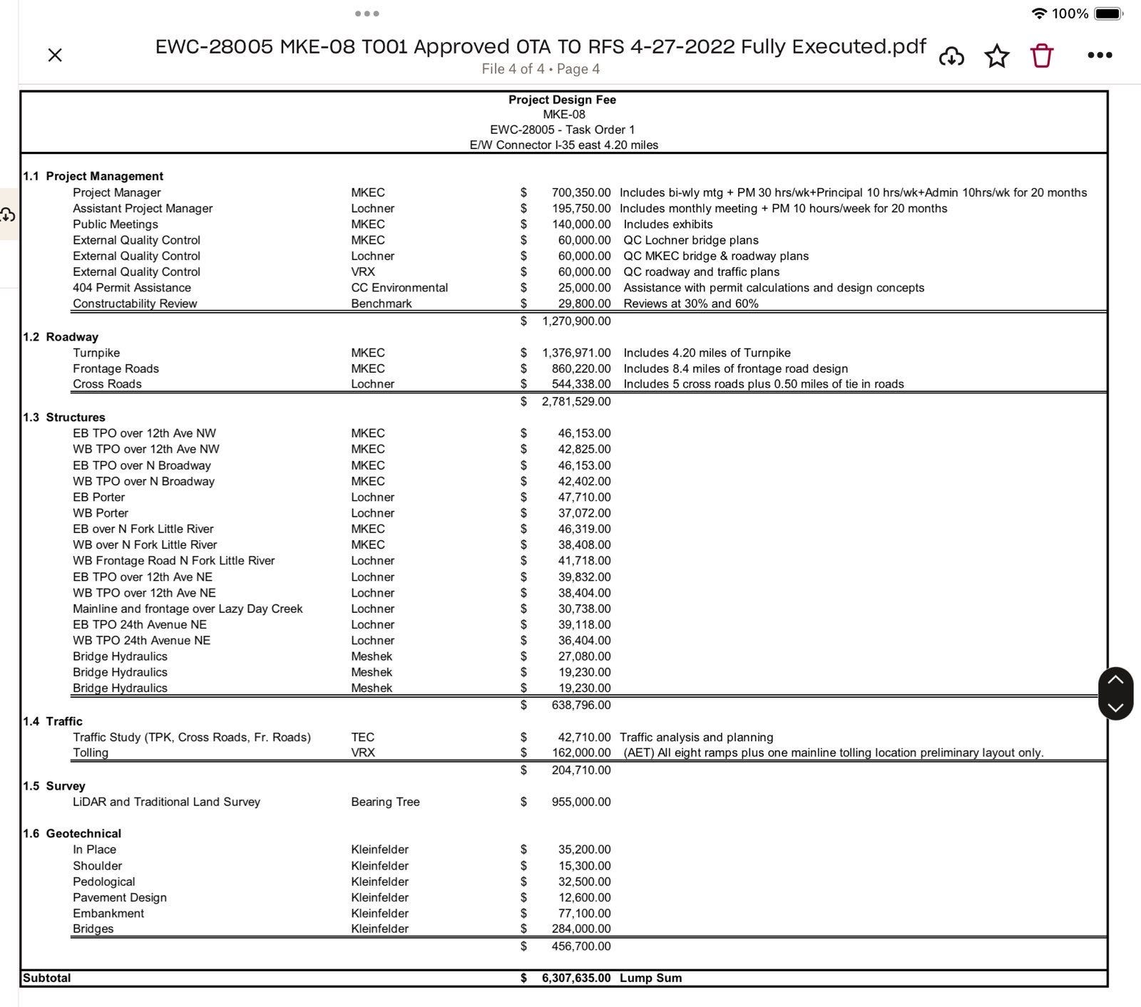
I have a more detailed view for the segment along the east-west corridor shown in GREEN. This particular segment is being designed by MKEC under project number EWC-28005. Their contract was originally upwards of $6.2 MILLION to design these ~4.5 miles.
This ~4.5 mile segment is where folks received certified letters from POE and Associates telling them that surveyors would be asking to enter their land. Read my previous post about how to refuse access to your land.

You will want to focus on the red lines here as they are the RIGHT OF WAY extents. I have broken this ~4.5 mile segment into FIVE pieces below so you can see more detail.
This ~4.5 mile segment runs south of Indian Hills. Indian Hills acts as the North service road for the on-off ramps to the west-bound two-lane toll road. There is a new service road shown on the south side with on and off ramps to the east bound two-lane tollroad.
There are two interchanges proposed along this stretch. One at 12th Ave NW (Bryant Ave) and the other at 12th Ave NE (SH77).
You will note that in the task order approval from April 27, 2022, “major cross road construction and/or widening included within this scope include 12th Ave. NW, Broadway Ave, Porter Ave, 12th Ave. NE and 24th Ave NE.” That means that significant right-of-way will be required for about 1200 feet north and south of the proposed turnpike alignment along those cross-streets.
Pay attention. Is your house and property in the Right-of-Way? We want to hear from you!
Also note that the task order says “fifteen bridges will be located within,” but on the plans, I see only three.

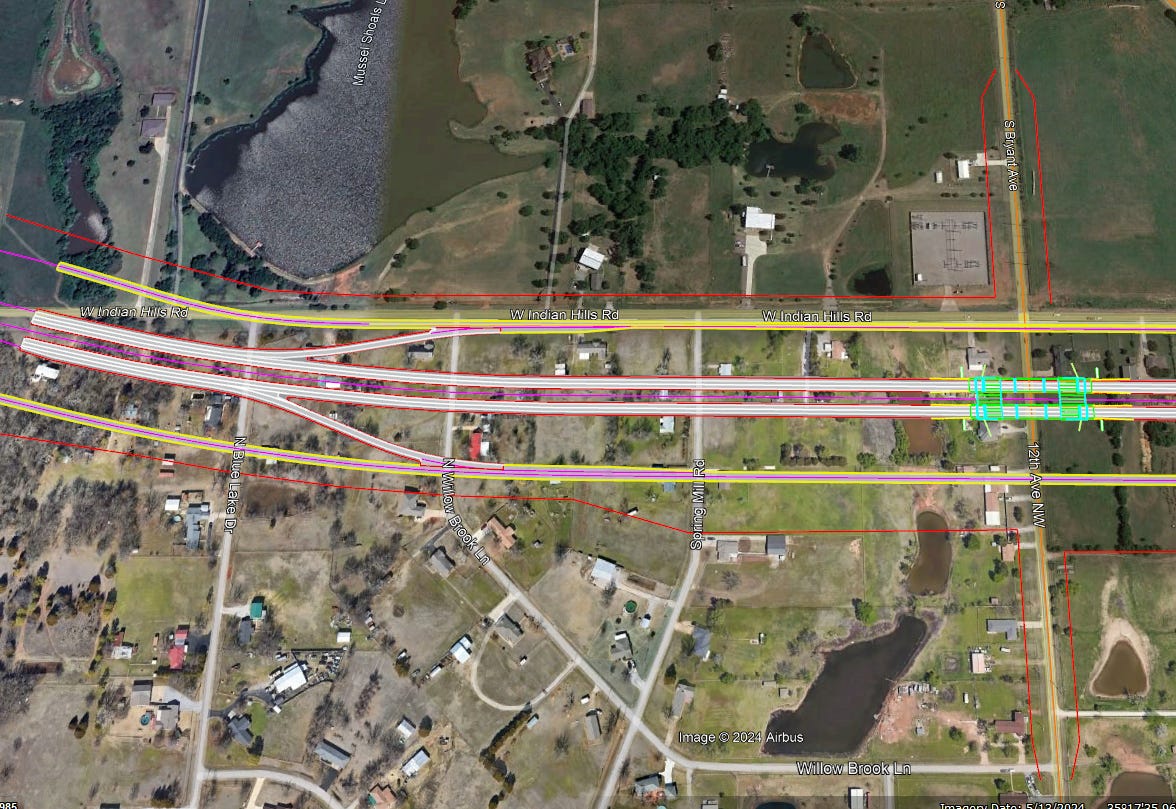
First Segment
The first segment (from west to east) goes OVER (TPO) 12th Ave NW/Bryant and a bridge is shown on the plans. You can also see the red line which is the Right-of-Way (ROW) extents.
Notice the ROW extending north and south on S. Bryant Ave and 12th Ave NW, respectively. This is the ROW necessary to run the county road UNDER the turnpike.
Second Segment
The next segment is the Broadway crossing. The plans show a toll road bridge with the turnpike over (TPO) Broadway. That means that Broadway will go UNDER the turnpike.

Third Segment
The next segment east is the North Porter and Little River Crossing. The crossing at North Porter doesn’t show a bridge, so it is unclear if North Porter will go OVER or UNDER the turnpike and the task order doesn’t specify. My guess is that there will be a bridge here and Porter will go UNDER the tollroad.
There is a bridge shown over the Little River. This is within the watershed of Lake Thunderbird and is the inflow to our drinking water.

Fourth Segment
The next segment east is the SH77 crossing and interchange. Note that no bridge is shown here, but it is anticipated that SH77 will go UNDER the turnpike (at least according to the April 2022 task order).
How deep is the water here now when it rains? What happens when this roadway dives deeper underground? Does the design call for a pump? If the pump fails, who is in charge of maintaining it? The County? The City?

Fifth Segment
The next segment is the 24th Ave NE crossing, where the turnpike design has currently halted due to not knowing where the southern extension will meet the east-west connector. Note that 24th Ave NE must be re-aligned to the east to avoid Sunset Memorial Park Cemetery. Also note that no bridge is shown on the plans at this cross-over, but according to the April 2022 task order, the turnpike will go OVER 24th Ave NE.

Why this Route?
There is a lot of low lying areas along this route where creeks run into our drinking water source. These areas are shown in blue. The turnpike is proposed to cross these creeks within our impaired water shed numerous times.

We all know these turnpikes have nothing to do with alleviating traffic or improving safety, so I won’t bore you with the obvious. But do ask yourself who will benefit from this toll road. It definitely is not the people who live here or the locally owned small businesses, farms and ranches.
Why is our City willing to let an unnecessary tollroad be built that will allow travelers to bypass our businesses, further decimate our watershed and displace thousands of tax-paying residents? They have the power to withhold work permits. Why aren’t they?
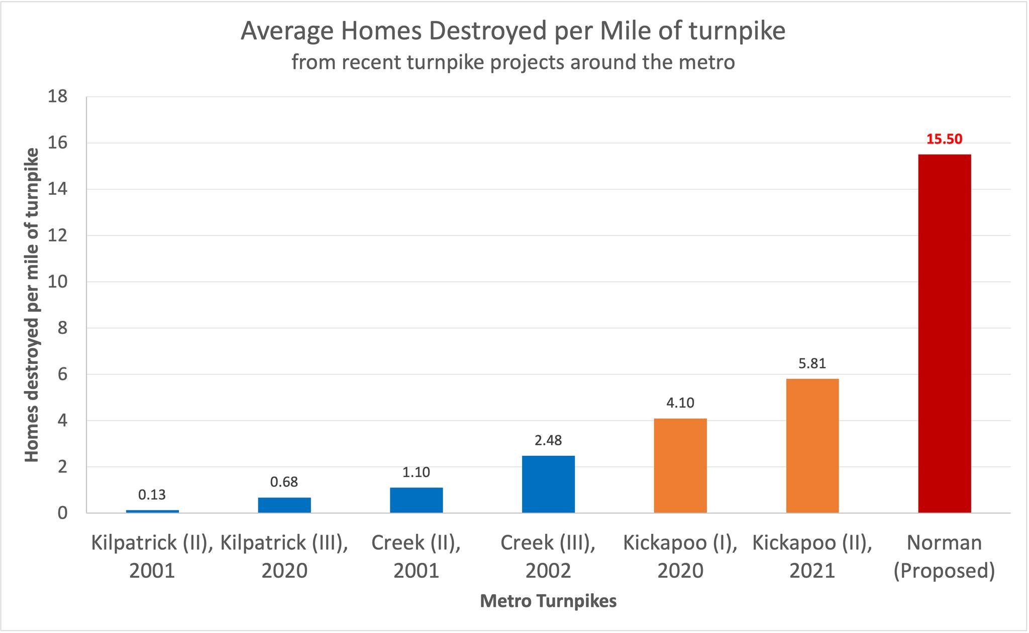
The OTA is planning on destroying our county roads, Little River Greenbelt, watershed and rural community to build a turnpike that isn't needed. When are more people going to get really mad and help us fight this?
PIKE OFF OTA (501 c4) and Oklahomans for Responsible Transportation, Foundation (501 c3) are leading the charge in legal injunctive avenues and legislative reform and they could use your help. They are trying to dismantle a corrupt Goliath within our state and are doing a great job. Be part of the solution!