


Cooking the Books on Safety: How OTA Twists Data to Push Toll Roads
Exposing the misleading numbers behind the I-35 Corridor turnpike push—because Oklahomans deserve the truth, not toll-funded fiction.

The Oklahoma Turnpike Authority (OTA) has emphasized safety as a key reason for the proposed new turnpike alignments in Cleveland and McClain Counties. OTA officials stated that the new turnpikes are needed to alleviate growing traffic congestion along I-35 in the Oklahoma City metro area.
I provided their traffic modeling and inflated projections in a recent Substack but I wanted to give you a bit more information about why these routes don’t make sense so you can pushback *with data* on the gaslighting you are going to hear this week about why the turnpikes are necessary.

Where are most trucks headed if they are traveling north from Texas on I-35? TO OKLAHOMA CITY. Typically, they are headed the industrial/commercial areas which reside mostly on the WEST SIDE or they are headed through OKC to Edmond up I35. There aren’t many locations where these trucks are going EAST of OKC.
I had GROK (AI) give me a scatter plot of a few commercial trucking companies, furniture manufactures, chemical manufacturing and Amazon docks in OKC. These obviously aren’t all of them, but you get the point.

The ZERO (0) point on the x-axis means that anything to the LEFT of zero is WEST and anything to the RIGHT of zero is EAST. The ZERO (0) point on the y-axis means that anything BELOW zero is SOUTH and anything ABOVE zero is North.
Most of the commercial trucking docks that I mapped are WEST of the City. Specifically SouthWest.
Except Amazon. Hmmm…..
Why would most of the trucking traffic want to bypass I-35 and drive EIGHTEEN (18) MILES East of OKC to just have to turn around and head west on I40, or continue north on the Kickapoo to I44 to presumably go to Tulsa?
Trucks coming from Tulsa to Dallas (or Dallas to Tulsa) would not utilize the proposed toll roads through Norman because it adds time and miles to their route – They would use Route 69.
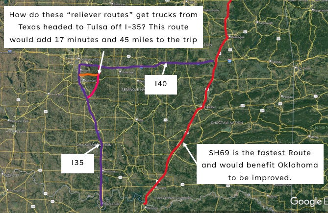
Interestingly enough, ODOT was looking at upgrading Route 69 in the past because more trucks actually use U.S. 69 than use I-35 and it is a major route for Texans driving through Oklahoma to Tulsa and Chicago. The executive director of the Durant Chamber of Commerce said that “Truckers and travelers coming north out of Texas on their way to major cities north and east of here know that they can cut 70 miles off their trip by coming through Durant. Another benefit is that they can avoid two major metropolitan areas in OKC and Tulsa, and that is also a time-saver.”
The Intermodal Surface Transportation Efficiency Act (ISTEA) of 1991 specifically authorized the highway be upgraded and made a part of the interstate highway system. In 1999, the Oklahoma Transportation Authority (formerly and currently the Oklahoma Turnpike Authority), spent $190K on a preliminary study of the highway to determine if a parallel tollway, upgrading the existing highway as a state-supported road or building toll lanes alongside the existing state highway 69 would be the most feasible. Please ask the Oklahoma Turnpike Authority for their January 2000 feasibility report on Route 69 and why they haven’t pursued that project. Why is the OTA not focused on areas of the state where their investments would be welcomed to solve actual traffic concerns?
In addition, the federal government is planning and funding a new interstate corridor in Western Oklahoma called the Ports-to-Plains Corridor that will span from Laredo, Texas on the Mexican border, up through Lubbock and I27, the Oklahoma panhandle and to the Canadian border to handle long-haul truck traffic. It is fully funded by the 2022 omnibus appropriations bill.

The Ports-to-Plains Corridor is meant to provide "a continuous North American freight route through three partner organizations spanning the US. The interstate designation enables state DOTs to use funds to create the freight route with new construction and adding on existing roads (such as state highways that will be converted to become part of I-27)." I-27 is a FEDERALLY FUNDED interstate highway that will pull congestion off of I-35. We do not need turnpikes to displace hundreds of Oklahomans when the Federal Government is funding the expansion of an existing corridor that will better serve traffic needs.
Where is the regional planning that the Oklahoma Turnpike Authority engaged in that showed the necessity of these turnpikes?
Oh right… they DID NOT PARTICIPATE IN ACOG’s 2045 plan!


Additional newstory here.
RUSH HOUR TRAFFIC
The OTA claims that the congestion during rush hour is the traffic being addressed. The small window of time that there is traffic on Route 9 between I-35 and the University during peak commuting times is due to a failure of traffic engineering – too frequent and mistimed lights. The small window of time that there is traffic on I-35 during peak commuting time is ALSO due to a failure of traffic engineering – poor interchange and on/off ramp geometry.
In fact, the ODOT agrees and is currently in Phase 1 of a study that extends from south of Robinson Street in Norman to north of SW 4th Street in Moore because “this section of I-35 in Moore and Norman has been plagued with operational challenges due to increased traffic and development and unique geometry that creates a section that is inconsistent throughout. This study aims to bring a level of consistency to both the frontage roads and the interchanges with its final proposal.”
The OTA reasoning that they will alleviate the commuter traffic off of I35 with the proposed east-Norman alignment turnpikes is a falsehood. No east Norman commuter is going to use these toll roads to travel to OKC because the connection to I-40 is 18 miles east of OKC. In addition, the proposed Outer-Loop: East-West Connector would dump traffic from Norman and Newcastle onto I-35 at a location that the OTA says is already too congested – Indian Hills. These proposed routes WILL NOT solve the traffic congestion along I-35 – and in fact, will exacerbate it.
With the current and future planned ODOT improvements to existing corridors like the ODOT widening Route 9 and Route 102 to four lanes, the current, planned, funded and approved improvements to I-35 interchanges (e.g., SH9W and Indian Hills), along with improvements to some of the rural two-lane roads in Cleveland County, travel will be safer and more efficient. New turnpike alignments are not needed.
SAFETY
Additionally, the OTA highlighted that the South Extension Turnpike aims to serve as a traffic reliever route for the congested I-35 Southern Corridor by moving heavy truck traffic out of the city center, thereby improving safety by lessening congestion between Purcell and Oklahoma City.
In terms of safety, the OTA claims that accidents and deaths on I-35 are the motivation to relieve this congestion at rush hour. Crashes occur as frequently on weekends as they do on weekdays and accidents and deaths occur at all hours along the I-35 corridor. An analysis of the OHSO Interactive Crash Map shows that the accidents along the I-35 corridor do not seem to be correlated with traffic congestion, but rather with driver behavior such as drugs, alcohol or high speed and traffic engineering inadequacies, such as merge length and geometry of on/off ramps (e.g., I-240, 12th Street, 19th Street, Indian Hills and SH9W Interchange areas).
INJURY ACCIDENTS
I plotted the available injury crash data for you in the following graphs. Please note that as of May 18, 2025, injury crash data is only available through the 2021 calendar year.
I plotted both the total crashes on I35 from (Texas to Kansas) and the split between fatal, serious and minor versus total crashes in the Study Zone split between fatal, serious and minor. The study zone was I35 crash data between Purcell and I40.
This website only contains INJURY accident information.

Here I plot the 2020 annual injury crashes on I-35 both by total (Texas to Kansas) and in the Study Zone (Purcell to I40) by HOUR.

And here I took just the injury crashes that occurred in the Study Zone (Purcell to I40) and plotted them by hour.
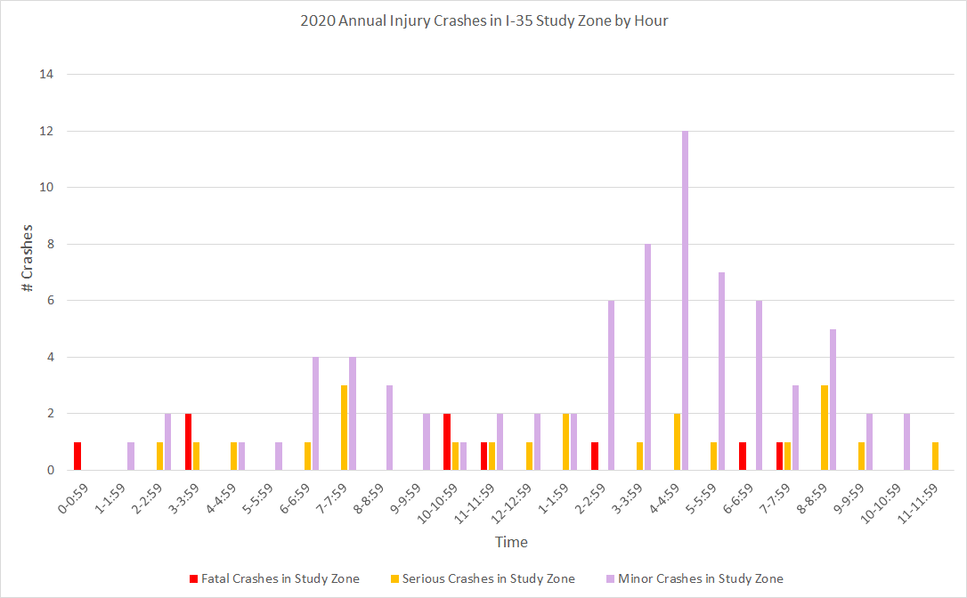
What do you notice? That most of the fatal and serious injury accidents occur when there is free flowing traffic - at HIGH SPEEDS. High speed (and drugs/alcohol) is listed as a reason for all of the fatalities, and a majority of the serious injury accidents.
Most of the minor accidents occur around the afternoon rush hour, however, please note that from 2 to 8 pm, for the ENTIRE 2020 YEAR, there were only 42 minor injury crashes in the study zone and they all occurred within 1/4 mile of an interchange.
Now before you say… BUT IT WAS 2020 when we were all “flattening the curve,” and working from home.
I get it.. but the state of Oklahoma works at a glacial pace and is obviously behind on uploading the crash data to this site, and I haven’t had a chance to delve into the 2021 data yet. I’ll work on plotting out the 2021 data in the coming weeks, but from a cursory survey of the dots on the website, it doesn’t change much from 2020.
If you want to see for yourself, click on the website link. But I’ll warn you. It’s time consuming to manually collect all the injury accident data from the website. You have to zoom in and manually click on every one of those little dots (yellow = minor, red = serious and black = fatal). You have to zoom in to ensure that the accident happened on I-35 and not a service road or feeder road overpass.
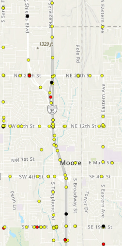
And then you have to read the description to see what happened. For example, this fatality in Moore, occurred on April 1, 2021 between 8-8:59 pm and was alcohol and speed related. Plus there is a lot more data if you scroll down, like this was NOT a teen or older driver and it was not drug related.

And don’t get interupted when you are halfway through the state because you’ll have to start over. Do I have any volunteers that want to help with the 2021 data?
If I really knew how to use AI, this chore should be way faster.
NON-INJURY ACCIDENT DATA
But you know what else is timeconsuming? Trying to get NON-INJURY ACCIDENT DATA! No joke. And the OTA used that to provide justification of why the turnpikes were needed. That’s another one of their big lies. They inflated their accident data and provided a false narrative misrepresenting the number of collisions occurring on I-35 by counting collisions on interstate overpasses, I-40, I-240, SH-9W. They also counted crashes from the proposed interchange north of Purcell to Purcell, and also crashes south of Purcell.
Check this OTA presser out.


Hey! Remember this colorful graph from the last substack.. you know.. the INFLATED TRAFFIC PROJECTIONS? When the OTA creates propaganda, they throw it out there with abandon in the hopes that people will start believing it’s true. DO NOT BELIEVE THE LIES.
The OTA press release of January 11, 2023 listed a total of 1,827 “Reported crashes between I-40 and Purcell” with a link titled “2019 data” allowing a reader to view the file they used to provide information.
The spreadsheet lacked information to properly evaluate crashes occurring on I-35. Additional data such as direction of travel, type of collision and more detailed location information was needed to properly evaluate number of crashes.
Additional information was requested through an open record request from the Oklahoma Highway Safety Office (OHSO), a program of the Oklahoma Department of Public Safety, and later received. It showed a total of total of 1,827 collisions, in the so-called I-35 corridor occurring in 2019.
Upon reviewing more detailed information from the Oklahoma Department of Public Safety some red flags appeared.
An examination of the data showed a significantly lower number of collisions than was listed in the press release.
The information supplied by the Oklahoma Highway Safety Office (OHSO) was queried to isolate direction of travel for rear-end type collisions. It was discovered that out of the 1,827 collisions listed a total of 317 collisions involved eastbound or westbound vehicles.
How can eastbound and westbound collisions occur on I-35, a north-south interstate highway? The simple answer is they can’t. These 317 collisions, 17.4% of the total, did not occur on I-35 and do not have an impact of the I-35 traffic.
The Oklahoma Turnpike Authority inflated crash numbers on I-35 by at least 22% by including side street traffic data—an egregious and misleading tactic. It’s either the result of a rushed, poorly executed study or a deliberate attempt to misinform the public to justify their toll road agenda. Either way, it's unacceptable.

The corrected numbers also decreased the average daily collisions from 5 per day to 4.1 per day.
Because PIKE OFF OTA researchers are the best in the state, and just to be THOROUGH, we submitted several additional Open Record Requests for data for 2020-current. Unfortunately, OHSO could not fulfill those requests for some reason and pointed us to Service Oklahoma, who apparently is now the state agency in charge of collecting and publishing those statistics.
Did you know that?
Why on earth is the Oklahoma Department of PUBLIC SAFETY handing over the collection of critical safety data, gathered by trained safety officers, to Service Oklahoma—a tag agency that’s supposed to handle driver’s licenses, vehicle registrations, and hunting permits, not vital law enforcement data?
This is public safety, not paperwork.
Who’s making these reckless decisions?
I have more to say on this safety mess, but this problem is tangential, although contributing, to the turnpike authority’s bad transportation planning policies. So I’m going to just show you the trail of open record requests and leave it at that for now.

and it goes on, but you can tell that our researchers know their stuff.
Here’s the follow up….
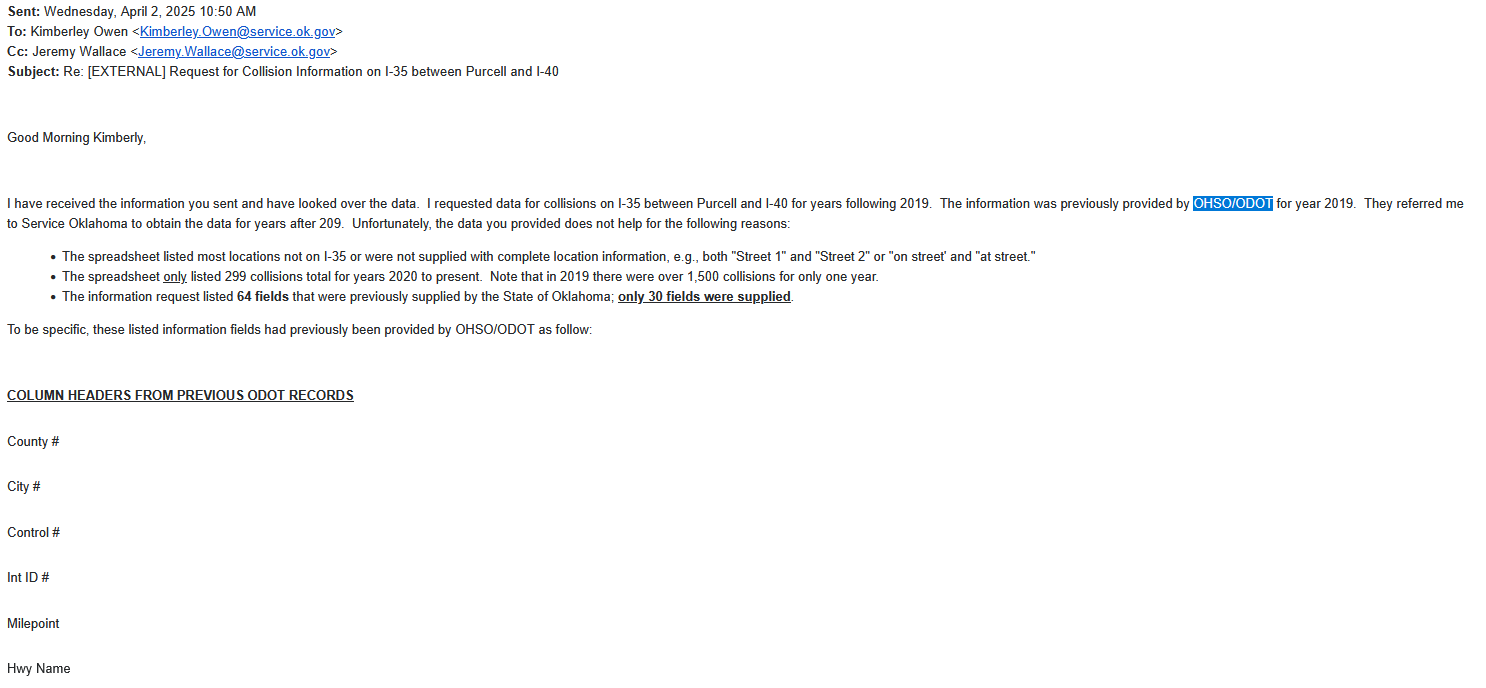


We got this reply….


And we still don’t have resolution.
I really want to know… where is the accident data that is collected by our safety officers going? Why can’t Service Oklahoma search the database by GEOGRAPHY and provide non-injury crash data along I-35? Why haven’t they sent us their database for us to sort through?
Whether it’s gross mismanagement, willful obstruction, or just plain indifference or incompetence, the job isn’t getting done—and Oklahomans are paying the price.
And the bigger question is HOW CAN OTA MAKE A SAFETY CLAIM WHEN THE SAFETY DATA IS M.I.A.?
And, how can the OTA get away with inflating the 2019 I-35 accident data to justify the turnpikes?
Shouldn’t they have to show several years of data and do a bonifide traffic safety study that is independently verified and then work with the Association of Central Goverments on traffic safety patterns in the REGION before throwing down a tollroad route?
Oh wait.
THE TOLLROADS HAVE NOTHING TO DO WITH TRANSPORTATION OR SAFETY.
Ask the questions. Know the facts. The more we push back, the more they shrink. Something’s gotta give.


Amy,
This is so very good. Keep the spotlight on them. I linked to this story at the end of a story I posted today here https://arnett.substack.com/p/flooding-neighbor-property-in-catoosa
Hello Amy,
My name is Linda Diepenbrock. I have lived in Norman since 1981 and on E. Cedar Lane Rd since 1996. I am a retired Engineer and Educator, currently serving our community as a N.Am.Mission Bd.- endorsed Chaplain. I have prepared notes to speak tonight should the opportunity present itself. You can reach me at 405-306-3530. This pic is Mother's day with my daughter, Leslie, who is currently on the Bd. Of CCFI, and formerly co-owner of BOLD.
My speech is not a sermon, but more of a treatise for change. BIG CHANGE!!!
I am the short one! I will try to wear heels tonight. 😁