Does this land-use map look good to you?
500-acre industrial tracts are great for watersheds right?
We know now that the City Staff knew about the turnpike routes well before the public did and more concerningly, have been directly working with the OTA, developers and private engineering consultants against the will of the citizens. They have done all of this without alerting the Council Members or Citizens to their plans. In fact, they have willfully hidden the information from the Council Members and citizens; until we got these emails.
This begs several questions… If they were brazen enough to email about their disdain for the “pike people” and “opposition,” while falling all over themselves to assist the OTA, developers, and Chamber of Commerce, what have they talked about “offline?”
And who actually runs the City? The staff or the elected officials?
2045 *Draft* Comprehensive Landuse Plan
The City of Norman established the Aim (Area & Infrastructure Master Plan) Norman Comprehensive Plan Steering Committee in August of 2023. The purpose of this committee is to create a 2045 Land Use Plan for Norman, to replace our existing 2025 Land Use Plan.
AIM Norman should look at several distinct elements of city infrastructure, services and growth, including:
Comprehensive Land Use Plan
Housing Market Analysis & Affordability Strategy
Comprehensive Transportation Plan Update
Stormwater Master Plan Update
Water Master Play Update
Wastewater Master Plan
Parks Master Plan
The AIM Steering Committee is supposed to complete their plans over 16-20 months (~December 2024 - April 2025). This Committee is facilitated by RDG Planning and Design, Inc. and Garver Engineering, who, as you know, is the Assistant Corridor Manager for the Oklahoma Turnpike Authority’s proposed turnpikes through Norman.
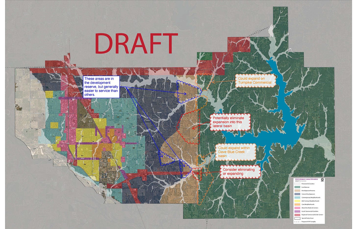
On May 29, 2024, RDG sent the following email and “Character Areas” map to the City of Norman and Garver engineers. The RDG Principal wanted to make sure they caught any “red flags…. before this goes out to committee this week.”
A “Character Areas” Map is a broad look at a community to identify places that show a common form of development and land use pattern, lifestyle or “feel” that collectively define the overall character, whether existing or intended in the future.
Apparently RDG and Garver (and the City Staff) *FEELS* like the proposed east-west connector turnpike should be commercially developed through our watershed (shown in RED = Regional Commercial and Job Centers) and *FEELS* like there should be a perfectly linear development stop right around 80th Ave (shown as TAN = Development Reserve).
What’s at 80th Ave? Oh yeah…. the proposed SOUTHERN EXTENSION TURNPIKE that was denied passage by the Bureau of Reclamation.
Tell me again that these turnpikes are for transportation needs and not busting the current land-zoning in east Norman.
In case you didn’t catch it in the emails, the comment bubbles on the map were put there by Garver Engineers in response to the first map sent by RDG. Note that in one orange comment bubble the Garver Engineers, who are making millions of dollars working for the turnpike while simultaneously being paid by the City of Norman to help with the “comprehensive land plan,” say they “could expand on Turnpike Commercial.”
Hahaha…. Look where that comment bubble is pointing to! Right along the Little River. Is Garver, the “environmental stewards” of Norman, actually suggesting we put commercial and industrial sites deep IN OUR WATERSHED? Say it ain’t so.
Current 2025 Land Use Plan
Can you even remember what our CURRENT 2025 Land Use Plan looks like? Let me refresh your memory. The urban core stays (for the most part) west of 48th east and the suburban residential is west of 60th. Everything east of 60th is “country,” as it should be.
and it says rational, common sense things like…..
The 2025 Land Use Plan specifically said that between Franklin and Indian Hills from Broadway (just west of Porter) to 72nd N.E. the City of Norman wanted to “protect the Little River watershed and tributaries, and create a sense of visual, physical separation between Norman and Moore.”
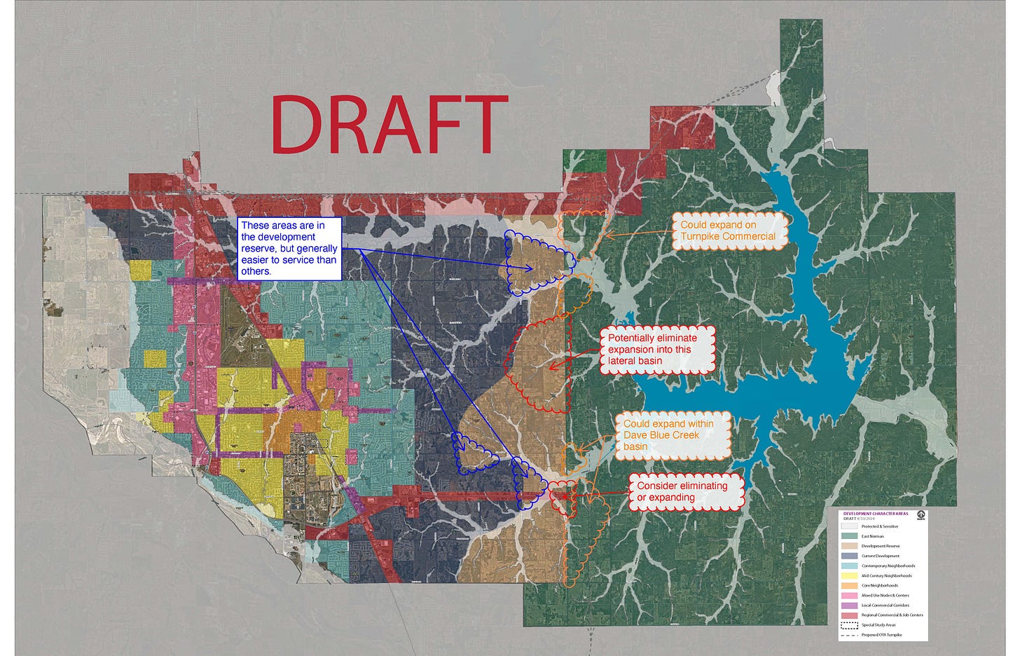
And now, in the 2045 Land Use Plan, we have this one-mile wide swath of planned COMMERCIAL ZONING in an area previously undeveloped or used for agricultural? An area that was to “protect the Little River Watershed?”
Wow. Our unelected City Staff have done a 180 degree turn on its citizens.
And note the crickets in the email chain. Note that NOT ONE City of Norman Staff wrote back and said “Major red flags folks. It is a BAD idea to develop our green belt along Indian Hills within the Little River Watershed. It is a bad idea to allow more than 1 house per 10 acres out to 80th.”
What do the City Staff actually think about a development plan like this?
500-acre Industrial Site on 72nd N.E. and Indian Hills
THEY LOVE DEVELOPMENT. They love it so much, they use exclamation points when discussing how much they want to pave over east and north Norman.
Way back in February of 2023, there was a city staff exchange that started with an exuberant email about the possibility of being the next “Pryor, Oklahoma” in bringing a “500-acre industrial site with sewer, water, power and high speed internet” to Norman. Apparently, according to the Secretary of Commerce at a Chamber of Commerce Meeting, “there is only 1 “Mega Site” in the entire state of Oklahoma for industrial development,” and the City Staff were beside themselves to “provide some large spaces [for industrial development] in the new Comp Plan update!”
I didn’t add the exclamation point. The City Staff did.
Then the next staff responded with not one, but FOUR exclamation points when they shouted “YES!!!! [Staff] start working your numbers! LOL!”
I don’t know what Slide 12 was, or what this staff member is going to preach to the business community, but wait for it.
Then, on Valentine’s Day 2023, some lovely staff member wrote this to the team:
If the text in the email is too small for you to read, let me repeat it loud and clear:
“An ideal location to zone a large industrial tract would be at the southwest or southeast intersection of the Kickapoo Turnpike South Extension and the East-West Turnpike (roughly 72nd N.E. and Indian Hills Road)…..All sorts of warehousing and industrial operations will be attracted to those new interstate routes….”
Love, Hugs and Kisses Norman Citizens and your Environment!!!!!!!!!
Love, Your City Staff!!!!!!!
Now this is where the groomer steps in and says… HELL YEAH folks. When our bought-off Supreme Court Justices say we can do this, let’s make sure we pick the right people for our AIM Comprehensive Steering Committee and have them present this masterful development plan it so we don’t look like the bad guys. We need developers, bankers, financiers, Chamber of Commerce folks… but screw those crazy “pike people” in Ward 5. Keep them off it. Repeat after me… WE LOVE CONCRETE and industrial waste in our water!
Ok.. I made that up, but you get the gist of the email right?
And this kind of back-door, blatantly dangerous pro-development nonsense within the City Staff is how we ended up with a 2045 Land Use Plan that looks like this:


This plan has been taking place without input from the public. What about talking with the people who live there and have abided by the city’s rules of development since 1970’s?
What kind of turnover has there been in the City Staff ranks? When I see "Chamber of Commerce" I think former State Representative Scott Martin. Again, as I have asked in the past, why did he leave the legislature before term limits forced him out? I think it is obvious now.
The Turnpike, UNP Arena TIF, and aggressive changes in city government show a couple of things. Oklahoma City Metro sprawl has reached a critical mass in Cleveland County. Developers are ready to pounce on the opportunity and are expending great energy to do so. Second, a growing set of trusting (gullible) Norman residents fell asleep and allowed the election of development operatives.