


OTA Dodges Federal Permits by Artificially Restraining Canadian River between bridge piers
Double Standards at Play: How the OTA Skirts Oversight and Accountability

What do our bloated government entities who are charged with protecting the citizens, the environment and our representative democracy actually do FOR the people? Let me cut to the chase. It’s all a facade for the grifters. It doesn’t matter who sits at the top of the food chain.
You and I, for example, have to follow the laws of the land and be compliant little worker bees or we face denials, fines and/or loss of freedoms. But the governmental agencies, public-private-partnerships and the folks who benefit from the billions of fiat bond money make it their mission to have a different set of rules.
USACE exempts OTA from Section 404 Clean Waters Act permit
In April 2024, the Oklahoma Turnpike Authority and their engineering and environmental consultants met with the United States Army Corps of Engineers (USACE) to “reintroduce the ACCESS Program,” and let them know that the OTA was going to construct a 7,000 foot long bridge across the South Canadian River for a new turnpike within the ACCESS program - The East-West Connector (EWC-28002).
According to TJ Dill, former Deputy Director of the OTA (and currently the Chief Engineer at ODOT), the “East-West Connector between I44 and I35 is OTA’s highest priority.”

** We know the OTA met to discuss the permitting process across the South Canadian River with the USACE because of documents received through a Freedom of Information Act (FOIA) request made to the USACE Tulsa District Counsel on September 9, 2024. The same request was made to the Oklahoma Turnpike Authority (OTA) through an Open Record Request (ORR) on August 6, 2024, however, no documents were produced. **
The meeting minutes from the initial April 12, 2024 meeting between the OTA and the USACE reflect that “the USACE can move forward without AJDs and it’s preferable to circumvent AJDs for wetlands, if possible.” They want to circumvent these AJDs and delineate the water features as “ponds and ephemeral streams,” because these types of features are not jurisdictional and would not elevate the permitting process to the Environmental Protection Agency (EPA) headquarters, which take time.
What’s an AJD and PJD? Approved jurisdictional determinations (AJDs) and preliminary JDs (PJDs) are tools used by the U.S. Army Corps of Engineers (USACE) to help implement Section 404 of the Clean Water Act (CWA) and Sections 9 and 10 of the Rivers and Harbors Act of 1899 (RHA).


According to the meeting minutes, the USACE said that “Garver may submit 404 permits without AJDs for the priority projects due to time constraints.”
WHAT TIME CONSTRAINTS? There is no deadline for this project.
Then on June 19, 2024, Garver reached back out to their “USACE Friends,” and said that “As an effort to minimize impacts to the Canadian River, the OTA has determined that they can build the new river crossing without any work within the OHWM of the channel.”
OHWM = Ordinary High Water Mark

The OHWM defines the lateral extent of aquatic features in the absence of adjacent wetlands. The federal regulatory definition of the OHWM is “that line on the shore established by the fluctuations of water and indicated by physical characteristics such as a clear, natural line impressed on the bank, shelving changes in the character of soil, destruction of terrestrial vegetation, the presence of litter and debris, or other appropriate means that consider the characteristics of the surrounding areas.”
Apparently, the OTA and their engineering consultants were already besties with the USACE permitting team. How convenient!
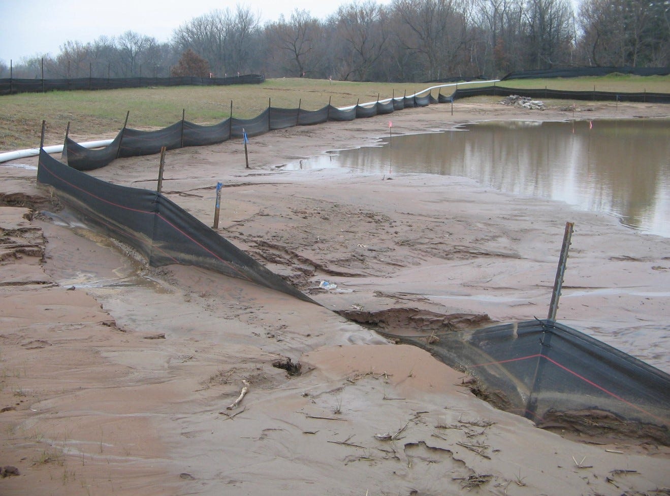
Artificially Constraining a Meandering River to avoid permits
The OTA and their consultants are trying to convince the USACE that they don’t need a permit because they say their bridge piers will never come in contact with the river.
They make the argument, that in a mile-wide flood plain, where the river channel has moved over a MILE in 40 years alone, that the ordinary high water table of the current channel will NEVER TOUCH THEIR BRIDGE and thus, they should be exempted from the permitting process.
Huh. What do you think about that argument?
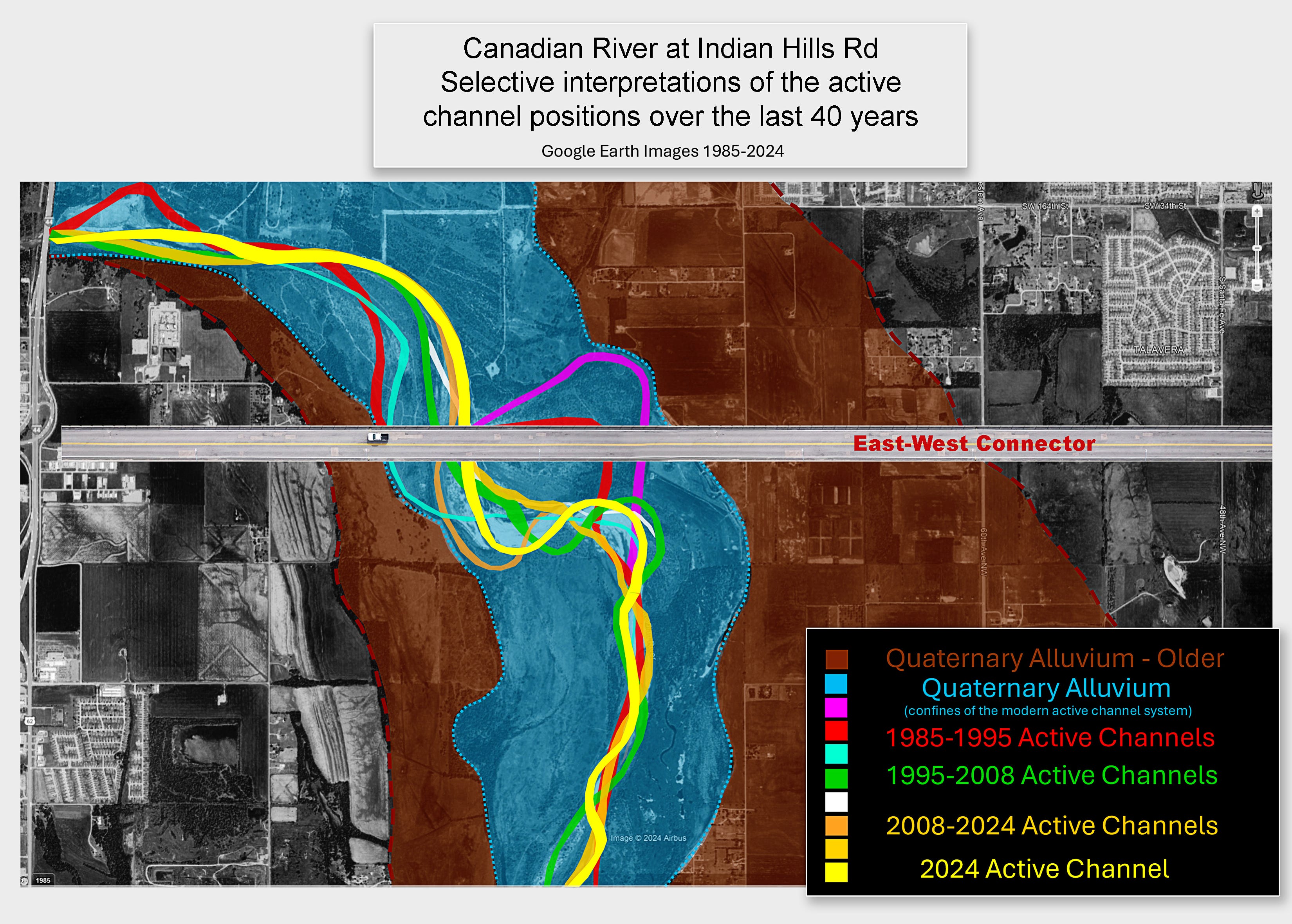
This interpretation of the laterally meandering Canadian River in its modern Quaternary valley was based on 1) publicly available Google Earth images, 2) the Geologic Map of the Oklahoma City South 30x60-Minute Quadrangle, Canadian, Cleveland, Grad, Lincoln, McClain, Oklahoma, and Pottawatomie Couties, Oklahoma, by Thomas Stanley, 2021, and 3) The National Map online data viewer provided by the USGS.
The historical survey maps show that the entire area in and around the sweep of the Pink channel was carved out of the ancient Quaternary alluvium valley during the period of 1873 to 1948. According to those maps, the eastern bank of the Canadian river evolved eastward by roughly ½ mile from 1873 to 1948.
The historical survey maps and the modern Google Earth imagery show that the Canadian River is a dynamic system, with a meandering active channel that has, from time to time, occupied every part of the Blue-shaded modern Quaternary river valley, and could reoccupy any portion of said valley in the future.
OTA’s consultants ignore Mother Nature and Arbitrarily pick a location for the river channel
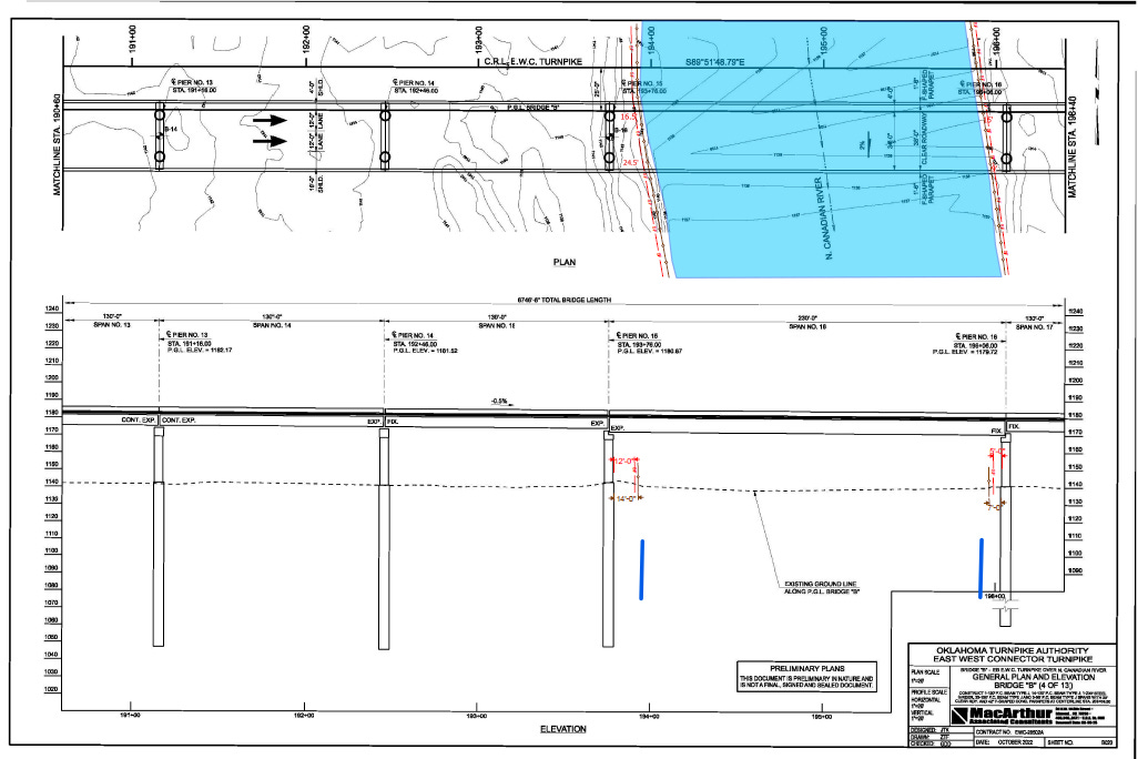
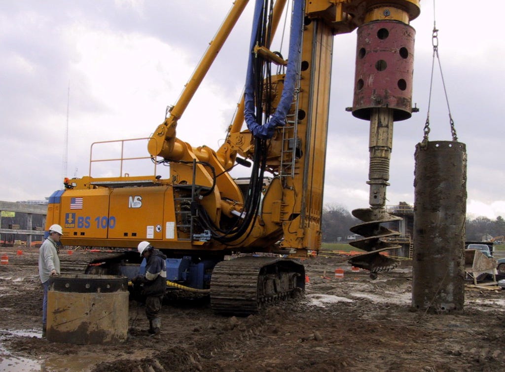
In mid June (June 16, 2024) the USACE was sent two cross sections showing both east- and west-bound bridges across the river as proof that they should be exempted from the 404 permitting process.
The MacArthur derived planned elevation of the west bound span shows a snapshot of the 7,000 foot long bridge across the Canadian River that crosses the river channel. The schematic shows several pier locations between repeating 130' foot bridge spans until the river channel is encountered. Here, at the “current” river channel location, shown in blue, the bridge piers widen to 230 feet to “accommodate” the water without the “ordinary high water mark” of the channel interacting with the bridge piers.

The ordinary high water mark (OHWM) is shown in the red and brown dimensions and is meant to show that the river channel will stay away from the bridge piers in that span.
Over the past 40 years, the main river channel has been in FIVE distinct paths across a mile-wide “wetland” area. Common sense says that the OHWM of this river is not static, nor does the soil type (sand) allow for any sort of physical indication of a channel that routinely runs in the same path.
The east bound bridge section over the river channel shows a similar analysis. The river channel is shown artificially constrained within a 230 foot span. In addition, the surveyed existing groundline, shown in the dotted black line, is presented.
These calculations are curious.
First, they are woefully inadequate. There was no back up documentation included within the FOIA request to indicate the assumptions or calculations used to determine the OHWM and the OTA did not provide any additional information.
Secondly, they are woefully deceiving.
As shown in the historical satellite imagery presented, this South Canadian River is clearly a meandering river system. The channel hasn’t “STAYED” in one place for very long. From 1985 until present, the active channels have moved back and forth across almost a mile wide path where the turnpike proposes to cross.
In addition, in a meandering river system, where the predominant soil across the river system is sand and the elevation is relatively flat, the existing groundline is constantly changing as the river system periodically floods. The soil type and the relatively flat elevation with limited vegetation in the river system is why the active river channel is able to jump around so broadly. And that’s why the flood plain is so wide.
You can see how wide the South Canadian River system became after a large rain event in 2015 shown in the video below. The water jumped the channel and flooded several residences between Moore and Norman. During a flooding event like this, the water would impact any bridge piers across the system. And after this flooding event, the river channel would assuredly move outside of any 230 foot span the bridge design contained.
(Start the video at 1:37 and watch until about 4:37 and look how wide the channel became, encroaching on adjacent properties. Turn the sound off. The drone makes a lot of noise).
So how can the OTA claim that the river won’t touch their bridge piers and that they should be exempted from a 404 flooding permit?
Shouldn’t they be REQUIRED to conduct an environmental impact study on how the construction of their bridge and the presence of their bridge in perpetuity would impact the river channel?
You and I can’t touch or build anything within a water quality protection zone without significant fines or worse punishment - especially when there are endangered species present.
And the South Canadian River contains an endangered species, which I wrote about back in September of 2024. The Arkansas River Shiner (ARS).

So shouldn’t the US Fish and Wildlife Service (USFWS) and the Oklahoma Department of Environmental Quality (ODEQ) on behalf of the Environmental Protection Agency (EPA) get a chance to review the impacts prior to exempting the OTA from any sort of permit to cross the river with a 7,000 foot bridge consisting of HUNDREDS of bridge piers penetrating the meandering river bed and natural habitat to an endangered species?
The OTA did report to the USACE that they were setting up a meeting with the USFWS on April 23, 2024 to discuss the “ACCESS program and [Endangered Species Act] ESA consultation.”
But, let’s be honest. If the trained and educated engineers at the USACE believe that the Ordinary High Water Mark (OHWM) of a MEANDERING RIVER CHANNEL will not touch the 7,000 foot long bridge and the hundreds of piers, and the river channel and its inhabitants will not be impacted by a structure or dredged material, how can the USFWS get involved to determine the impact to the fish and wildlife?
No matter what you think about protecting endangered species, clean water or prime agricultural land, we pay taxes that bankroll government agencies created to *supposedly* protect our land, wildlife, waterways and private property. These regulatory agencies should hold everyone to the same high standards during major infrastructure projects through sensitive waterways to ensure all known, perceived and possible impacts are disclosed and mitigated.
So why was the OTA given a permit exemption on a billion dollar, 7,000 foot long bridge that will alter the course of the river and affect, in perpetuity, the wildlife that lives there?
Hierarchy of Permitting Processes and Backroom Dealing
If the Bureau of Land Management (BLM) owns the river channel, the U.S. Fish and Wildlife Services (USFWS) are in charge of ensuring our built environment doesn’t negatively impact our fish and wildlife and the Oklahoma Department of Environmental Quality (ODEQ) on behalf the Environmental Protection Agency (EPA) is in charge of ensuring that our water quality is not impacted, why haven’t they weighed in?
Because the United States Army Corps of Engineers (USACE) is the head of the permitting food chain.
The permitting starts with the USACE.
If the USACE exempts an entity from the Clean Water Act Section 404 permits for the discharge of dredged or fill material into waters of the US, then the ODEQ and USFWS and BLM never SEE the project. The Clean Water Act Section 401 certification review is never triggered.
The Oklahoma DEQ conducts Clean Water Act Section 401 certification reviews of projects requiring a federal discharge permit. The Federal Environmental Protection Agency (EPA) ceded their permitting power to the ODEQ. The most common federal permits in Oklahoma requiring 401 certifications are Clean Water Act Section 404 permits from the USACE for the discharge of dredged or fill material into waters of the US.
If the USACE deems the project to not impact the river channel, then the USFWS and the BLM never get to weigh in. If the ENGINEERS at the USACE tell the BIOLOGISTS at the USFWS that the river channel won’t be impacted, then the USFWS review will never happen.
Those agencies are never asked to weigh in on the potential impacts if the USACE exempts the OTA from a Section 404 Permit.
Now do you see what is going on?
The OTA and their consultants are obfuscating the truth by convincing the USACE that a historically meandering river channel will stay within an arbitrarily delineated 230 foot wide location under their bridge and that their construction material will not reach and impact the water quality of the river channel or wildlife habitat.

On July 2, 2024, the OTA and their consultants met again with the USACE via Teams. The OTA’s consultants gave the USACE a “refresher on EWC-28002” and to make their case for an their exemption from the 404 flooding permit, said they would not put any permanent fill in the existing river channel because their piers were outside the ordinary high water mark (OHWM).


They went on to say that they would put no temporary construction roads within the OHWM.
Then they said that if they did have to get into the river, they would get in touch with the USFWS to talk about the Arkansas River Shiner.
Does anyone really think that the OTA will initiate that conversation without a lawsuit compelling them to do so?

Then, in order to sound genuine in their intentions to not impact the river channel, they invited the USACE to conduct a site visit to “confirm [the] OHWM.”
Wow. Do you think the USACE is going to take them up on that invitation prior to giving them a formal exemption letter?
At the end of the meeting, in minutes proudly taken on OTA ACCESS OKLAHOMA letterhead, they said that their Best Management Practices (BMPs) include marking of the OHWM for avoidance, putting the construction fences at least two feet beyond the OHWM extents and using a silt fence two feet beyond that so that dredged material from their pier excavation doesn’t get into the river channel.
I’m sure silt fences are going to be the ticket to protecting our water! For sure!

The OTA’s environmental guru’s said that when submitting a Pre-Construction Notification (PCN), they would “clearly articulate that the project will avoid the placement of fill within the OHWM of the Canadian River.”
Then they said that they would “confirm that Lost Creek is not considered critical habitat for the [Arkansas River Shiner] ARS.”

Articulate and confirm.
Wow.
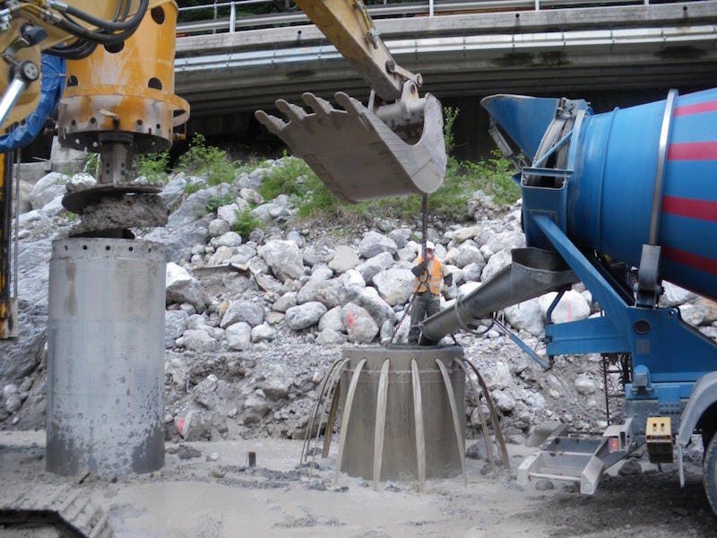
What great verbs to describe how an agency with an unlimited fiat revenue bond money spigot is going to ensure that a 7,000 foot long bridge, supported by hundreds of large-diameter piers drilled through a sandy-silty river bottom and into bedrock requiring tens of thousands of cubic yards of concrete won’t negatively affect the river, the water quality or the mile-wide sensitive ecosystem or the up- and downstream hydraulics.
I feel so protected.
The OTA can “articulate” all they want on permits to try and slide this through, but I want to see a multi-year study on all the impacts of their billion dollar bridge project so that a quality mitigation plan can be designed, reviewed, implemented and constructed properly.
We know from many of their previous turnpike projects that the OTA does nothing to mitigate flooding and damages to adjacent properties or waterways.
Once the turnpike construction is done, they wipe their hands clean and leave the affected adjacent property owners to fend for themselves and pay for all the damages that the turnpike created.
The USACE has the ability to force the OTA to complete real studies.
The OTA has access to BILLIONS OF DOLLARS OF REVENUE BONDS.
They have the money to pay for quality studies. They’ve known they wanted to build this bridge for at least FOUR YEARS.
Why will they NEVER PERFORM IMPACT STUDIES?
Why is the USACE allowing the OTA to turn in a few pieces of paper with well “articulated” assurances that they won’t affect the OHWM and do a BILLION DOLLAR PROJECT with absolutely ZERO permitting requirements?

After this meeting, the USACE assigned the EWC-28002 Canadian River Crossing bridge project an internal number: SWT-2024-0035. Apparently there was no permit application filed. The number was created based on the meetings and discussions with the OTA.

Who is going to hold the OTA Accountable?
Clearly the South Canadian flooding events are significant and any infrastructure built in and on that flood plain will impact the river channel, adjacent farmland, downstream properties and any wildlife that lives on, in or around the river - endangered, threatened or just trying to live in peace.
These types of rivers flood regularly, which is why there are multiple historic active river channels spanning only a few decades and why the flood plain is so wide. Some of the most fertile farmland in Oklahoma is found alongside flooding rivers. The ecosystem depends on it.
But apparently the OTA can harness Mother Nature and constrain the river channel to a 230’ wide single path that will never touch their bridge?
And they can convince our USACE regulatory agency that they shouldn’t have to conduct any impact studies that show the short- and long-term effects of their bridge?
I’m not just talking about the increased sediment load during construction. I’m talking about the microplastic and petro runoff as well as vibration, light, thermal and noise pollution.
Surely the OTA’s environmental studies guru knows how meandering river channels work, right? Surely they know what a diverse and important ecological system a meandering river channel is, right?
Surely the engineers at the USACE regulatory office know?
And if they know, why would they pretend that the river channel is going to miraculously stay in the 230-foot pier span of the bridge?
Why would they be amenable to grant the OTA an exemption from completing ANY IMPACT STUDIES required for the permitting process?
Why would they not automatically trigger the ODEQ water quality certification or USFWS impact mitigation plan by forcing the OTA to go through the 404 flooding permit process?
Why does the USACE persist in disregarding established principles of stream morphology and neglect its taxpayer-funded responsibility to provide proper regulatory oversight of the OTA?

Apparently, in the world of permitting, it's not what you’re building or how much your structure will affect everything around it that matters. It’s who you are and how much grift you bring to the table.
It’s almost like the system isn’t broken—it’s working exactly as intended.

scratch some of that. I was reading this on my phone last night. Should have used my computer screen as I did this morning. Still, the emails/notes are leaving out the conversations and logic around how some of these decisions have been/are being made.
Nationwide permit 14 could cover a project like this, provided those conditions are met; however, the wording in the emails/meeting minutes you’ve presented is confusing regarding 404 applicability.
For instance, if no 404, then why file a PCN?
The early 2024 email concerning USFW and OTA uses the term-of-art “consultation” - so apparently, the project has formally been discussed with them was considered covered under USACE jurisdiction (at least at that time).
However, there’s nothing in what you’ve presented about consultation with Tribes or the SHPO which would also be part of the NWP process.